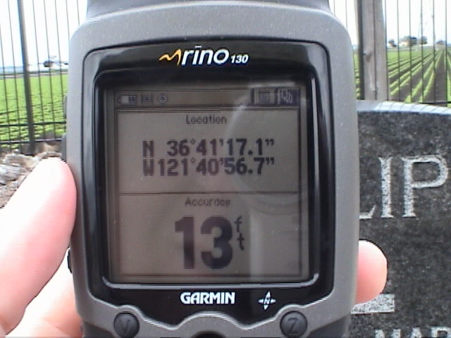
My Garmin GPS unit at the grave marker of Frank and Marian Phillips at the
Salinas Old Calvary Cemetery. DMS (degrees-minutes-seconds) units were used in 2006. [digital video frame]
Map Coordinate Use
GPS map coordinates in DMS (WGS 84)
My Garmin GPS unit at the grave marker of Frank
and Marian Phillips at the
Salinas Old Calvary Cemetery. DMS (degrees-minutes-seconds) units were used in
2006. [digital video
frame]

One of my GPS units at a grave marker at the
Hills Ferry Cemetery near Newman, CA.
It is in DM mode (degrees-minutes)
GPS (global positioning satellite) technology is ideally-suited for cemetery studies as well as in other aspects of family history research. Grave sites are often difficult to find in cemeteries, even in relatively small cemeteries. Once the GPS coordinates readings are made the site can be easily re-located by anyone using a handheld GPS unit, such as the ones shown in the photos above.
GPS navigating devices can also assist you in finding the cemetery. The handheld device as shown above can guide you to the cemetery or a GPS unit designed for navigating in a vehicle should do well. The vehicle type of GPS unit can usually be programmed with the street address of the destination and then it will guide you there.
GPS Measurement Formats
In 2007 I switched to the use DM (degrees-minutes) format, that is, the use of degrees with decimal minutes to express map coordinates. As shown on the GPS unit above the latitude is given as 37°19.973'. The 37° is 37 degrees. The 19.973' is 19.973 minutes. Just as there are 60 minutes in an hour there are 60 minutes in a degree. Similarly, both in time units and map units there are 60 seconds in a minute.
The DM format is the main GPS system and it is easy to use for data collection in small areas. In a small area like a cemetery a field worker would usually only have to collect only the decimal value for the seconds datum for each the latitude and longitude.
Field data are most easily collected with handheld GPS (Global Positioning Satellite) units. I used a Garmin Rino 130 on my first surveys in early 2006. My early data were collected in DMS format (degrees-minutes-seconds). In April of 2007 I switched to DM mode while using the Magellan eXplorist unit as shown in the second photo above.
Using data from my GPS unit and from the photographs that my wife and I took at the cemeteries I was able to identify the positions on the satellite and aerial photos available from TerraServer and from Google Earth. The TerraServer maps usually closely agreed with our field data. The Google Earth maps were usually 20-40 feet off in the Monterey County area but closer elsewhere. Map coordinates were verified and estimated to 0.1 to 0.01-second accuracy using a combination of GPS, ground photos and aerial photos. In most cases the latitude and longitude data given here will pinpoint the headstone or vault location to within about a meter, or about 3 feet.
The map coordinate values given in the database are sometimes entered in a way that the can be "copy and pasted" into map search utilities such as Google Earth, Microsoft Streets and Trips, DeLorme's Street Atlas USA or DeLorme's Topo USA. Of course all of these utilities have limitations about the way data may be entered.
The GPS-DM coordinates I measured as shown in the photo above are:
37º19.973' North latitude and 121°03.154' West longitude
In the database this position would be listed as:
37º19.973 N 121º03.154 W
or
37 19.973 N 121 03.154 W
The latter form may be copied and pasted straight into
many map utilities such
as Google Earth
to center the satellite photo on the location.
These coordinates can be
entered into a GPS unit as a waypoint or POI,
for example,
and be used to guide you to that spot from anywhere.
The DM data can be converted
to other forms, such as a decimal form or
DMS form with simple calculations as given below. Some computer software
and websites accept coordinates in only one specific format. Many websites
have unit conversion tools. I find it faster just to do the unit
conversion with
a simple calculator.